
Bishops Stortford Elsan Point topographic map
Interactive map
Click on the map to display elevation.
About this map
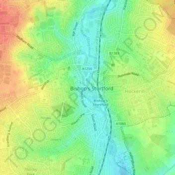
Name: Bishops Stortford Elsan Point topographic map, elevation, terrain.
Average elevation: 256 ft
Minimum elevation: 171 ft
Maximum elevation: 354 ft
Other topographic maps
Click on a map to view its topography, its elevation and its terrain.
Pelham Gate
United Kingdom > England > Hertfordshire > East Hertfordshire
Pelham Gate, Brent Pelham, East Hertfordshire, Hertfordshire, England, SG9 0HL, United Kingdom
Average elevation: 371 ft
Much Hadham
United Kingdom > England > Hertfordshire > East Hertfordshire
Much Hadham, East Hertfordshire, Hertfordshire, England, United Kingdom
Average elevation: 262 ft
Buntingford
United Kingdom > England > Hertfordshire > East Hertfordshire
Buntingford, East Hertfordshire, Hertfordshire, England, United Kingdom
Average elevation: 361 ft
Thorley
United Kingdom > England > Hertfordshire > East Hertfordshire > Thorley
Thorley, East Hertfordshire, Hertfordshire, East of England, England, United Kingdom
Average elevation: 269 ft