
武定县 topographic map
Interactive map
Click on the map to display elevation.
About this map
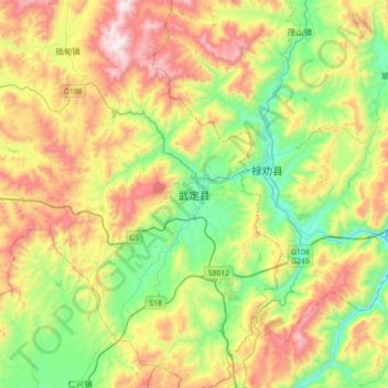
Name: 武定县 topographic map, elevation, terrain.
Location: 武定县, 狮山镇, 武定县, 楚雄彝族自治州, 云南省, 中国 (25.37313 102.24256 25.69313 102.56256)
Average elevation: 6,683 ft
Minimum elevation: 5,266 ft
Maximum elevation: 8,898 ft
武定县处于云贵高原西侧,地势东西两侧及西南部高,北部低,东西部较开阔。山区面积占96%。海拔最高点白龙会峰2,956米,最低点大沙地862米,平均海拔1,910米,县城狮山镇海拔1,712米。