
Make a donation
Gear up for your next adventure:
As an Amazon Associate, this site earns from qualifying purchases at no extra cost to you.
Valdivia topographic map
Click on the map to display elevation.
Make a donation
Gear up for your next adventure:
As an Amazon Associate, this site earns from qualifying purchases at no extra cost to you.
Valdivia
Within the context of plate tectonics, the city lies at a convergent margin where Nazca Plate, in the Pacific, is subducted beneath the South American Plate. Topographically Valdivia lies in a depression amidst the Chilean Coast Range. The basement rocks that crops out in the hills around the city are of metamorphic type. The city itself is chiefly built upon terraces made up of hardened volcanic sand. This volcanic sandstone is known as "cancagua" and deposited during the late Pleistocene epoch. As terraces took shape during the interglacial preceding the Llanquihue glaciation —the last glacial period— this interglacial is known in Chile as the Valdivia interglacial.
Make a donation
Gear up for your next adventure:
As an Amazon Associate, this site earns from qualifying purchases at no extra cost to you.
About this map
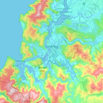
Name: Valdivia topographic map, elevation, terrain.
Location: Valdivia, Provincia de Valdivia, Los Ríos Region, Chile (-40.03202 -73.41394 -39.63708 -72.92085)
Average elevation: 469 ft
Minimum elevation: -10 ft
Maximum elevation: 2,313 ft
Make a donation
Gear up for your next adventure:
As an Amazon Associate, this site earns from qualifying purchases at no extra cost to you.
Other topographic maps
Click on a map to view its topography, its elevation and its terrain.
Panguipulli
Chile > Los Ríos Region > Provincia de Valdivia > Panguipulli > Panguipulli
Average elevation: 741 ft