
South Goa District topographic map
Interactive map
Click on the map to display elevation.
About this map
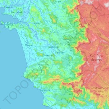
Name: South Goa District topographic map, elevation, terrain.
Location: South Goa District, Goa, India (14.75293 73.76020 15.53900 74.33792)
Average elevation: 646 ft
Minimum elevation: -10 ft
Maximum elevation: 3,340 ft
Other topographic maps
Click on a map to view its topography, its elevation and its terrain.
Querim (Kerim)
India > Goa > Pernem > Querim (Kerim)
Querim (Kerim), Pernem, North Goa, Goa, 403524, India
Average elevation: 82 ft
Butterfly Beach
Butterfly Beach, Canacona, South Goa, Goa, India
Average elevation: 92 ft
Anshi National Park/Tiger Reserve
Anshi National Park/Tiger Reserve, Sanguem, South Goa, Goa, India
Average elevation: 1,391 ft