
Galway City topographic map
Interactive map
Click on the map to display elevation.
About this map
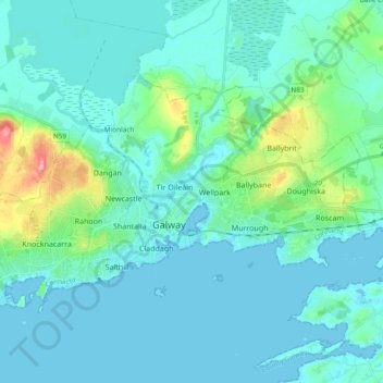
Name: Galway City topographic map, elevation, terrain.
Location: Galway City, Galway, County Galway, Connacht, Ireland (53.24852 -9.14269 53.31974 -8.95484)
Average elevation: 49 ft
Minimum elevation: -10 ft
Maximum elevation: 338 ft
Other topographic maps
Click on a map to view its topography, its elevation and its terrain.
Merlin Park
Ireland > County Galway > Galway
Merlin Park, Ballybane, Ballybaan, Galway, County Galway, Connacht, Ireland
Average elevation: 82 ft
Salthill
Ireland > County Galway > Galway
Salthill, Galway, County Galway, Connacht, Ireland
Average elevation: 30 ft