
Karavi topographic map
Interactive map
Click on the map to display elevation.
About this map
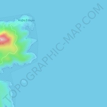
Name: Karavi topographic map, elevation, terrain.
Location: Karavi, Lasithi Regional Unit, Region of Crete, Crete, Greece (35.30741 26.31950 35.30774 26.31989)
Average elevation: 26 ft
Minimum elevation: -7 ft
Maximum elevation: 659 ft
Other topographic maps
Click on a map to view its topography, its elevation and its terrain.
Agios Nikolaos Municipality
Agios Nikolaos Municipality, Lasithi Regional Unit, Region of Crete, Crete, Greece
Average elevation: 702 ft
Kavousi
Greece > Crete > Κοινότητα Καβουσίου > Kavousi
Kavousi, Κοινότητα Καβουσίου, Lasithi Regional Unit, Crete, Greece
Average elevation: 988 ft
Kato Chorio
Greece > Crete > Kato Chorio
Kato Chorio, Ierapetra, Lasithi Regional Unit, Region of Crete, Crete, 72200, Greece
Average elevation: 705 ft
Piskopiano
Greece > Crete > Piskopiano
Piskopiano, Chersonisos Municipality, Heraklion Regional Unit, Region of Crete, Crete, 70014, Greece
Average elevation: 456 ft