
Herrö topographic map
Interactive map
Click on the map to display elevation.
About this map
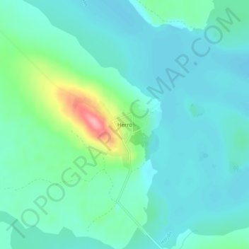
Name: Herrö topographic map, elevation, terrain.
Location: Herrö, Härjedalens kommun, Jämtland County, 842 94, Sweden (61.99616 14.17590 62.03616 14.21590)
Average elevation: 1,224 ft
Minimum elevation: 1,158 ft
Maximum elevation: 1,532 ft
Other topographic maps
Click on a map to view its topography, its elevation and its terrain.
Funäsdalen
Funäsdalen, Härjedalens kommun, Jämtland County, 840 95, Sweden
Average elevation: 2,192 ft
Strömsunds kommun
Strömsunds kommun, Jämtland County, Sweden
Average elevation: 1,558 ft
Sveg
Sveg, Härjedalens kommun, Jämtland County, 842 32, Sweden
Average elevation: 1,247 ft
Härjedalens kommun
Härjedalens kommun, Jämtland County, Sweden
Average elevation: 1,847 ft
Lockne
Lockne, Östersunds kommun, Jämtland County, Sweden
Average elevation: 1,142 ft
Arådalen
Arådalen, Bergs kommun, Jämtland County, Sweden
Average elevation: 2,831 ft