
Kebhach topographic map
Interactive map
Click on the map to display elevation.
About this map
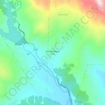
Name: Kebhach topographic map, elevation, terrain.
Average elevation: 1,434 ft
Minimum elevation: 942 ft
Maximum elevation: 2,785 ft
Other topographic maps
Click on a map to view its topography, its elevation and its terrain.
Tassart
Maroc > cercle de Tétouan > Al Oued > Tassart
Tassart, Al Oued, caïdat de Bni Hassan, Cercle de Tétouan, Province de Tétouan, Tanger-Tétouan-Al Hoceïma, Maroc
Average elevation: 2,060 ft