
Копичинці topographic map
Interactive map
Click on the map to display elevation.
About this map
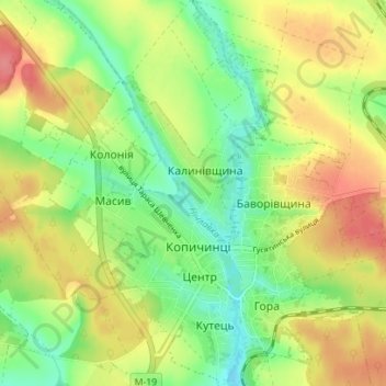
Name: Копичинці topographic map, elevation, terrain.
Location: Копичинці, Rajon Husjatyn, Oblast Ternopil, 48260, Ukraine (49.09041 25.87636 49.13607 25.93848)
Average elevation: 1,050 ft
Minimum elevation: 945 ft
Maximum elevation: 1,171 ft
Other topographic maps
Click on a map to view its topography, its elevation and its terrain.
Скала-Подільська
Скала-Подільська, Скала-Подільська селищна громада, Rajon Tschortkiw, Oblast Ternopil, 48720, Ukraine
Average elevation: 814 ft
Цигани
Цигани, Борщівська міська громада, Rajon Tschortkiw, Oblast Ternopil, 48712, Ukraine
Average elevation: 935 ft
Глинна
Ukraine > Oblast Ternopil > Глинна
Глинна, Козівська селищна громада, Rajon Ternopil, Oblast Ternopil, 47611, Ukraine
Average elevation: 1,168 ft
Залісці
Ukraine > Oblast Ternopil > Залісці
Залісці, Вишнівецька селищна громада, Кременецький район, Oblast Ternopil, 47310, Ukraine
Average elevation: 1,020 ft
Ternopil
Ukraine > Oblast Ternopil > Ternopil
Ternopil, Oblast Ternopil, 46000-46499, Ukraine
Average elevation: 1,119 ft