
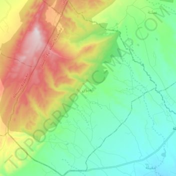
El Ayoun topographic map
Interactive map
Click on the map to display elevation.
About this map
Name: El Ayoun topographic map, elevation, terrain.
Location: El Ayoun, Cebalet Ouled Asker, Sidi Bouzid, Tunisie (35.26077 9.15007 35.37394 9.26689)
Average elevation: 2,087 ft
Minimum elevation: 1,342 ft
Maximum elevation: 3,609 ft
Other topographic maps
Click on a map to view its topography, its elevation and its terrain.
El Boua
Tunisie > Sidi Bouzid > El Boua
El Boua, Essed, Mezzouna, Sidi Bouzid, 9154, Tunisie
Average elevation: 305 ft
El Kharrouba
El Kharrouba, Menzel Bouzaïane, Sidi Bouzid, Tunisie
Average elevation: 978 ft
Parc National de Bou Hedma
Parc National de Bou Hedma, RR 124 طج, Et-Talh Est, Belkhir, Sidi Bouzid, Tunisie
Average elevation: 410 ft