Geolocate

Hope Town topographic map

Click on the map to display elevation.

About this map

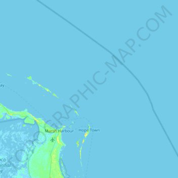
Name: Hope Town topographic map, elevation, terrain.

Location: Hope Town, Bahamas (26.39428 -77.21329 26.93462 -76.73281)

Average elevation: 0 ft

Minimum elevation: -10 ft

Maximum elevation: 75 ft

Other topographic maps

Click on a map to view its topography, its elevation and its terrain.

Duncan Town

Bahamas > Ragged Island

Average elevation: 7 ft

Royal Island

Bahamas > Spanish Wells

Average elevation: 0 ft

Rock Sound

Bahamas > South Eleuthera

Average elevation: 20 ft

Strangers Cay

Bahamas > Grand Cay

Average elevation: 0 ft

Gregory Town

Bahamas > Central Eleuthera

Average elevation: 30 ft

Hill Crest

Bahamas > New Providence

Average elevation: 23 ft

Dolphin Cay

Bahamas > Nassau

Average elevation: 13 ft

Anderson

Bahamas > Long Island

Average elevation: 10 ft

Great Abaco

Bahamas > North Abaco

Average elevation: 0 ft

Big Whale Cay

Bahamas > West Grand Bahama

Average elevation: 0 ft

Little Whale Clay

Bahamas > Berry Islands

Average elevation: 0 ft

Paradise Island

Bahamas > Nassau

Average elevation: 10 ft

Devil's Cay

Bahamas > Berry Islands

Average elevation: 3 ft

Gear up for your next adventure:

🪄Magnetic Compass - Accurate compass for navigation
🖼️Topo Map Wall Art - Decorative topographic prints of famous peaks and regions
📚Navigation Handbooks - Master the art of reading topographic maps and using a compass
🔥Camping Stove - Portable stove for camping and backcountry cooking
👟Trail Running Shoes - Lightweight shoes for trail runners

As an Amazon Associate, this site earns from qualifying purchases at no extra cost to you.