
Lotissement des Sapins topographic map
Interactive map
Click on the map to display elevation.
About this map
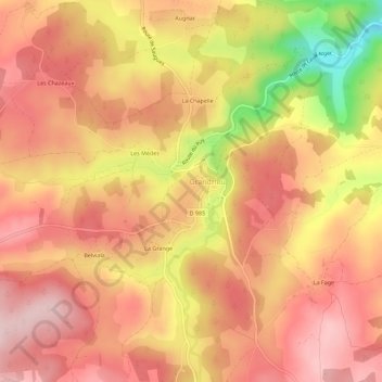
Name: Lotissement des Sapins topographic map, elevation, terrain.
Average elevation: 3,858 ft
Minimum elevation: 3,320 ft
Maximum elevation: 4,121 ft
Other topographic maps
Click on a map to view its topography, its elevation and its terrain.
Bellelande
France > Occitanie > Lozère > Grandrieu > Bellelande
Bellelande, Grandrieu, Mende, Lozère, Occitanie, France métropolitaine, 48600, France
Average elevation: 4,009 ft