
Neipel topographic map
Interactive map
Click on the map to display elevation.
About this map
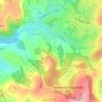
Name: Neipel topographic map, elevation, terrain.
Location: Neipel, Tholey, Landkreis St. Wendel, Saarland, Deutschland (49.46867 6.91160 49.48708 6.93694)
Average elevation: 1,155 ft
Minimum elevation: 879 ft
Maximum elevation: 1,480 ft
Other topographic maps
Click on a map to view its topography, its elevation and its terrain.
Theley
Deutschland > Saarland > Tholey
Theley, Tholey, Landkreis St. Wendel, Saarland, Deutschland
Average elevation: 1,280 ft
Hasborn-Dautweiler
Deutschland > Saarland > Tholey
Hasborn-Dautweiler, Tholey, Landkreis St. Wendel, Saarland, 66636, Deutschland
Average elevation: 1,276 ft