
Río Surco topographic map
Interactive map
Click on the map to display elevation.
About this map
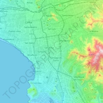
Name: Río Surco topographic map, elevation, terrain.
Location: Río Surco, Chorrillos, Lima, 15067, Peru (-12.20685 -77.03214 -12.02213 -76.93285)
Average elevation: 600 ft
Minimum elevation: -3 ft
Maximum elevation: 3,442 ft
Other topographic maps
Click on a map to view its topography, its elevation and its terrain.
Chorrillos
Peru > Lima > Chorrillos
Chorrillos, Lima, Lima Metropolitana, Lima, Peru
Average elevation: 112 ft