
Le Lernier topographic map
Interactive map
Click on the map to display elevation.
About this map
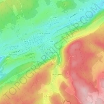
Name: Le Lernier topographic map, elevation, terrain.
Average elevation: 3,579 ft
Minimum elevation: 3,156 ft
Maximum elevation: 4,072 ft
Other topographic maps
Click on a map to view its topography, its elevation and its terrain.
Le Cernois
France > Bourgogne-Franche-Comté > Doubs > Chaux-Neuve
Le Cernois, Chaux-Neuve, Pontarlier, Doubs, Bourgogne-Franche-Comté, France métropolitaine, 25240, France
Average elevation: 3,770 ft