Geolocate

Banawang topographic map

Click on the map to display elevation.

About this map

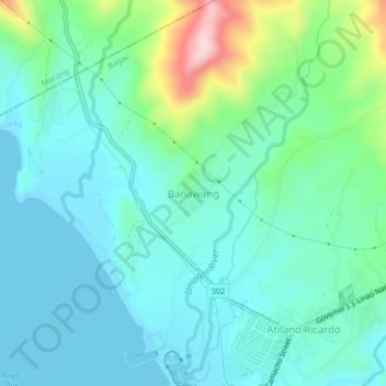
Name: Banawang topographic map, elevation, terrain.

Location: Banawang, Bagac, Bataan, Central Luzon, 2107, Philippines (14.60000 120.36702 14.64000 120.40702)

Average elevation: 194 ft

Minimum elevation: 0 ft

Maximum elevation: 915 ft

Gear up for your next adventure:

📦Gear Storage Bags - Organize and protect outdoor equipment
📱Solar Portable Charger - Solar power bank for charging devices off‑grid
📡Handheld GPS Device - Reliable handheld GPS for outdoor navigation
🔭Compact Binoculars - HD vision for scouting terrain and identifying distant landmarks
🪑Portable Camp Table - Compact table for campsite meals

As an Amazon Associate, this site earns from qualifying purchases at no extra cost to you.