Geolocate

Ridgeland topographic map

Click on the map to display elevation.

About this map

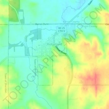
Name: Ridgeland topographic map, elevation, terrain.

Location: Ridgeland, Dunn County, Wisconsin, United States (45.19330 -91.90338 45.20852 -91.88826)

Average elevation: 1,135 ft

Minimum elevation: 1,063 ft

Maximum elevation: 1,247 ft

Dunn County trails, hiking, mountain biking, running and outdoor activities

Other topographic maps

Click on a map to view its topography, its elevation and its terrain.

Graytown

United States > Wisconsin > Dunn County

Average elevation: 1,129 ft

Caryville

United States > Wisconsin > Dunn County

Average elevation: 791 ft

Downsville

United States > Wisconsin > Dunn County

Average elevation: 837 ft

Rock Falls

United States > Wisconsin > Dunn County

Average elevation: 869 ft

Wilson Park

United States > Wisconsin > Dunn County > Menomonie

Average elevation: 876 ft

Canary Island

United States > Wisconsin > Dunn County > Menomonie

Average elevation: 1,014 ft

Gear up for your next adventure:

🔊Portable Camp Speaker - Music and alerts at camp
🌐World Map Poster - Decorative world maps with topographic info
🔌Solar Panel Charger - Charge gear sustainably outdoors
🗃️Trail First Aid Kit - Essential kit for outdoor injuries and emergencies
🪶Thermal Camp Blanket - Extra warmth for cold nights

As an Amazon Associate, this site earns from qualifying purchases at no extra cost to you.