
Make a donation
Gear up for your next adventure:
As an Amazon Associate, this site earns from qualifying purchases at no extra cost to you.
Guanajuato City topographic map
Click on the map to display elevation.
Make a donation
Gear up for your next adventure:
As an Amazon Associate, this site earns from qualifying purchases at no extra cost to you.
Guanajuato City
Although only one out of every 100 bodies interred in the cemetery became naturally mummified, the concentration of this phenomenon has led to theories about how they have come about. Some believe that they are the result of people who had been buried alive, after being mistakenly declared dead. These people, according to belief, died of desperation and asphyxiation and as a sign of their pain, convert into mummies. More commonly, it is likely the result of Guanajuato's altitude or the abundance of minerals in the soil. However, all of the mummified remains were found in the cemetery's above ground cement crypts, not in underground graves. Researchers believe the phenomenon is due to the warm, dry climate of the area, which dried out the bodies rapidly.
Make a donation
Gear up for your next adventure:
As an Amazon Associate, this site earns from qualifying purchases at no extra cost to you.
About this map
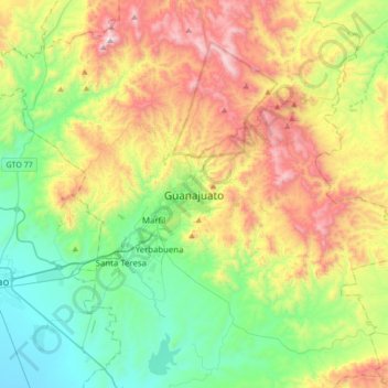
Name: Guanajuato City topographic map, elevation, terrain.
Average elevation: 7,159 ft
Minimum elevation: 5,741 ft
Maximum elevation: 9,652 ft
Make a donation
Gear up for your next adventure:
As an Amazon Associate, this site earns from qualifying purchases at no extra cost to you.