
Thank you for supporting this site ❤️
Make a donation
Make a donation
Gear up for your next adventure:
As an Amazon Associate, this site earns from qualifying purchases at no extra cost to you.
Trois-Ponts topographic map
Click on the map to display elevation.
Thank you for supporting this site ❤️
Make a donation
Make a donation
Gear up for your next adventure:
As an Amazon Associate, this site earns from qualifying purchases at no extra cost to you.
About this map
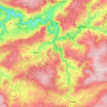
Name: Trois-Ponts topographic map, elevation, terrain.
Location: Trois-Ponts, Verviers, Liège, Wallonia, 4980, Belgium (50.31975 5.76023 50.39107 6.00204)
Average elevation: 1,348 ft
Minimum elevation: 594 ft
Maximum elevation: 1,985 ft
Thank you for supporting this site ❤️
Make a donation
Make a donation
Gear up for your next adventure:
As an Amazon Associate, this site earns from qualifying purchases at no extra cost to you.