
Schlachtensee topographic map
Interactive map
Click on the map to display elevation.
About this map
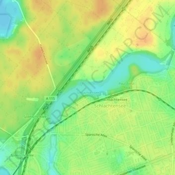
Name: Schlachtensee topographic map, elevation, terrain.
Location: Schlachtensee, Steglitz-Zehlendorf, Berlin, 14129, Germany (52.43612 13.19920 52.44639 13.22814)
Average elevation: 154 ft
Minimum elevation: 95 ft
Maximum elevation: 197 ft
Other topographic maps
Click on a map to view its topography, its elevation and its terrain.
Flughafensee
Flughafensee, Tegel, Reinickendorf, Berlin, 13405, Germany
Average elevation: 115 ft
Neu-Hohenschönhausen
Neu-Hohenschönhausen, Lichtenberg, Berlin, 13051, Germany
Average elevation: 187 ft
Schöneberg
Schöneberg, Tempelhof-Schöneberg, Berlin, Germany
Average elevation: 151 ft
Volkspark Humboldthain
Volkspark Humboldthain, Gesundbrunnen, Mitte, Berlin, 13355, Germany
Average elevation: 151 ft
Treptower Park
Treptower Park, Alt-Treptow, Berlin, 12435, Germany
Average elevation: 121 ft