
Make a donation
Gear up for your next adventure:
As an Amazon Associate, this site earns from qualifying purchases at no extra cost to you.
Canas de Senhorim topographic map
Click on the map to display elevation.
Make a donation
Gear up for your next adventure:
As an Amazon Associate, this site earns from qualifying purchases at no extra cost to you.
About this map
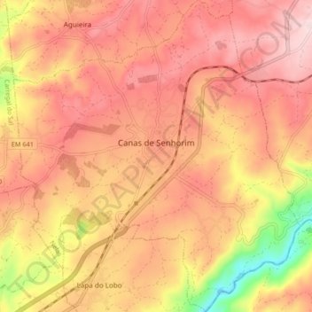
Name: Canas de Senhorim topographic map, elevation, terrain.
Location: Canas de Senhorim, Nelas, Viseu, Portugal (40.46916 -7.93903 40.53205 -7.86294)
Average elevation: 1,122 ft
Minimum elevation: 489 ft
Maximum elevation: 1,460 ft
Make a donation
Gear up for your next adventure:
As an Amazon Associate, this site earns from qualifying purchases at no extra cost to you.
Other topographic maps
Click on a map to view its topography, its elevation and its terrain.
Make a donation
Gear up for your next adventure:
As an Amazon Associate, this site earns from qualifying purchases at no extra cost to you.
Make a donation
Gear up for your next adventure:
As an Amazon Associate, this site earns from qualifying purchases at no extra cost to you.
Make a donation
Gear up for your next adventure:
As an Amazon Associate, this site earns from qualifying purchases at no extra cost to you.
Casal de Cima
Portugal > Viseu > Vilar de Besteiros e Mosteiro de Fráguas > Vilar de Besteiros > Casal de Cima
Average elevation: 1,109 ft
Pedreles
Portugal > Viseu > Fornos de Maceira Dão > Fornos de Maceira Dão > Pedreles
Average elevation: 1,467 ft
Make a donation
Gear up for your next adventure:
As an Amazon Associate, this site earns from qualifying purchases at no extra cost to you.