Geolocate

Goult topographic map

Click on the map to display elevation.

About this map
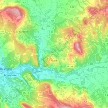
Name: Goult topographic map, elevation, terrain.

Location: Goult, Apt, Vaucluse, Provence-Alpes-Côte d'Azur, Metropolitan France, 84220, France (43.83884 5.19875 43.89629 5.29067)

Average elevation: 673 ft

Minimum elevation: 397 ft

Maximum elevation: 1,102 ft

Other topographic maps

Click on a map to view its topography, its elevation and its terrain.
Gear up for your next adventure:

🗻Climbing Gear Basics - Essential gear for beginner climbers
📷Action Cameras - Rugged cameras to document your journeys across rugged terrain
📌Outdoor GPS Map App - Apps and devices for digital topographic navigation
🥾Hiking Shoes - Durable and comfortable shoes for trail hiking
📚USA Hiking Guide Books - Top trail guides and map books

As an Amazon Associate, this site earns from qualifying purchases at no extra cost to you.