
Make a donation
Gear up for your next adventure:
As an Amazon Associate, this site earns from qualifying purchases at no extra cost to you.
Rio Branco topographic map
Click on the map to display elevation.
Make a donation
Gear up for your next adventure:
As an Amazon Associate, this site earns from qualifying purchases at no extra cost to you.
Rio Branco
Rio Branco is located at 9° 58' 29" south and 67° 48' 36" west, at an altitude of 143 metres (469 ft) above sea level. The city has developed on both sides of the Acre River, with areas known as the First (left bank) and Second Districts. The river is crossed by six bridges, the newest bridge being the Joaquim Macedo Catwalk.
Make a donation
Gear up for your next adventure:
As an Amazon Associate, this site earns from qualifying purchases at no extra cost to you.
About this map
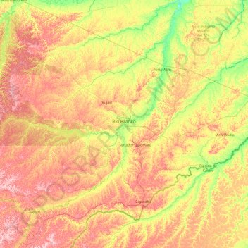
Name: Rio Branco topographic map, elevation, terrain.
Average elevation: 577 ft
Minimum elevation: 328 ft
Maximum elevation: 925 ft
Make a donation
Gear up for your next adventure:
As an Amazon Associate, this site earns from qualifying purchases at no extra cost to you.
Other topographic maps
Click on a map to view its topography, its elevation and its terrain.
Praça em homengem as vítmas de trânsito do Vale do Juruá
Brazil > Acre > Cruzeiro do Sul
Average elevation: 630 ft