
Cockle Bay topographic map
Interactive map
Click on the map to display elevation.
About this map
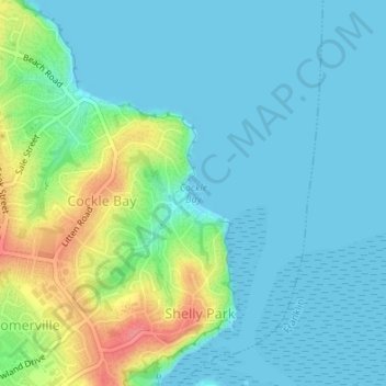
Name: Cockle Bay topographic map, elevation, terrain.
Location: Cockle Bay, Howick, Auckland, 2014, New Zealand (-36.89971 174.95100 -36.89961 174.95110)
Average elevation: 56 ft
Minimum elevation: 0 ft
Maximum elevation: 236 ft
Other topographic maps
Click on a map to view its topography, its elevation and its terrain.
Point View Reserve
New Zealand > Auckland > Howick
Point View Reserve, Mission Heights, Howick, Auckland, New Zealand
Average elevation: 194 ft
Buckland Beach
New Zealand > Auckland > Howick
Buckland Beach, Bucklands Beach, Howick, Auckland, New Zealand
Average elevation: 36 ft
Eastern Beach
New Zealand > Auckland > Howick
Eastern Beach, Howick, Auckland, New Zealand
Average elevation: 43 ft
Murphys Bush
New Zealand > Auckland > Howick
Murphys Bush, Donegal Park, Howick, Howick Ward, Auckland, New Zealand
Average elevation: 194 ft