
Eva Valley topographic map
Interactive map
Click on the map to display elevation.
About this map
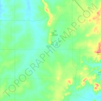
Name: Eva Valley topographic map, elevation, terrain.
Location: Eva Valley, Coomalie Shire, Northern Territory, Australia (-13.16228 130.95473 -13.10092 131.05918)
Average elevation: 318 ft
Minimum elevation: 207 ft
Maximum elevation: 591 ft
Other topographic maps
Click on a map to view its topography, its elevation and its terrain.
Adelaide River
Australia > Coomalie Shire > Adelaide River
Adelaide River, Coomalie Shire, Northern Territory, 0846, Australia
Average elevation: 200 ft
Batchelor
Batchelor, Coomalie Shire, Northern Territory, 0845, Australia
Average elevation: 312 ft
Adelaide River
Adelaide River, Coomalie Shire, Northern Territory, 0846, Australia
Average elevation: 223 ft
Rum Jungle
Rum Jungle, Coomalie Shire, Northern Territory, Australia
Average elevation: 259 ft
Batchelor
Australia > Coomalie Shire > Batchelor
Batchelor, Coomalie Shire, Northern Territory, 0845, Australia
Average elevation: 318 ft
Amangal
Australia > Coomalie Shire > Adelaide River
Amangal, Adelaide River, Coomalie Shire, Northern Territory, 0846, Australia
Average elevation: 210 ft