
Barcos topographic map
Interactive map
Click on the map to display elevation.
About this map
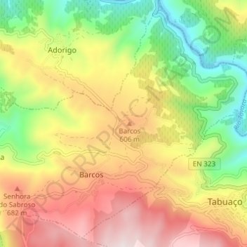
Name: Barcos topographic map, elevation, terrain.
Average elevation: 1,519 ft
Minimum elevation: 253 ft
Maximum elevation: 2,881 ft
Other topographic maps
Click on a map to view its topography, its elevation and its terrain.
Rio Tedo
Portugal > Norte > U.F Barcos e Santa Leocádia
Rio Tedo, U.F Barcos e Santa Leocádia, Tabuaço, Viseu, Douro, Norte, 5050-044 GALAFURA, Portugal
Average elevation: 1,719 ft