Geolocate

Palermo topographic map

Click on the map to display elevation.

About this map
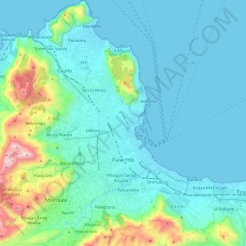
Name: Palermo topographic map, elevation, terrain.

Location: Palermo, Sicily, Italy (38.04991 13.24222 38.22459 13.45209)

Average elevation: 531 ft

Minimum elevation: -3 ft

Maximum elevation: 3,406 ft

Other topographic maps

Click on a map to view its topography, its elevation and its terrain.
Bellacera

Italy > Sicily > Palermo > Santa Flavia

Average elevation: 531 ft

Sorgente di Montescuro

Italy > Sicily > Palermo > Prizzi

Average elevation: 2,726 ft

San Carlo

Italy > Sicily > Palermo > Chiusa Sclafani

Average elevation: 955 ft

Finale

Italy > Sicily > Palermo

Average elevation: 276 ft

Santa Lucia

Italy > Sicily > Palermo > Cefalù

Average elevation: 167 ft

Gear up for your next adventure:

🪶Camping Sleeping Pad - Comfortable sleeping pad for backpacking
🪑Portable Camp Table - Compact table for campsite meals
👟Men's Trail Runners - Lightweight footwear for fast-paced exploration and light hiking
🚗GPS Dash Cams - Record your scenic drives through mountain passes and canyons
🎒Trekking Poles - Sturdy poles for balance and stability on rough terrain

As an Amazon Associate, this site earns from qualifying purchases at no extra cost to you.