Geolocate

Maleny topographic map

Click on the map to display elevation.

About this map

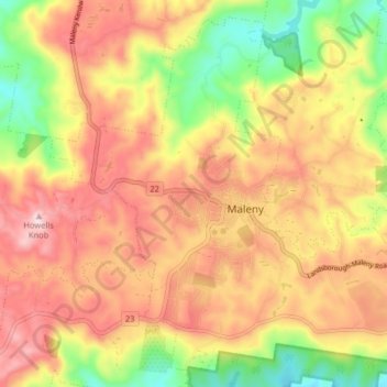
Name: Maleny topographic map, elevation, terrain.

Location: Maleny, Sunshine Coast Regional, Queensland, Australia (-26.78879 152.81233 -26.72281 152.89290)

Average elevation: 1,276 ft

Minimum elevation: 640 ft

Maximum elevation: 1,798 ft

Gear up for your next adventure:

☀️Outdoor Sunscreen - High protection sunscreen for outdoor activities
🔪Outdoor Multitools - Essential survival tools for gear repair and field use
🪄Magnetic Compass - Accurate compass for navigation
🎒Waterproof Dry Bags - Keep your electronics and maps dry inside your pack
🔊Portable Camp Speaker - Music and alerts at camp

As an Amazon Associate, this site earns from qualifying purchases at no extra cost to you.