
Thank you for supporting this site ❤️
Make a donation
Make a donation
Gear up for your next adventure:
As an Amazon Associate, this site earns from qualifying purchases at no extra cost to you.
Orjais topographic map
Click on the map to display elevation.
Thank you for supporting this site ❤️
Make a donation
Make a donation
Gear up for your next adventure:
As an Amazon Associate, this site earns from qualifying purchases at no extra cost to you.
About this map
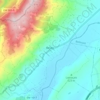
Name: Orjais topographic map, elevation, terrain.
Location: Orjais, Covilhã, Castelo Branco, Portugal (40.31625 -7.44253 40.36257 -7.37604)
Average elevation: 1,916 ft
Minimum elevation: 1,424 ft
Maximum elevation: 3,317 ft
Thank you for supporting this site ❤️
Make a donation
Make a donation
Gear up for your next adventure:
As an Amazon Associate, this site earns from qualifying purchases at no extra cost to you.
Other topographic maps
Click on a map to view its topography, its elevation and its terrain.
Poço do Forno Velho
Portugal > Castelo Branco > Covilhã > Cortes do Meio > Bouça
Average elevation: 2,936 ft