
Vieux Fort topographic map
Interactive map
Click on the map to display elevation.
About this map
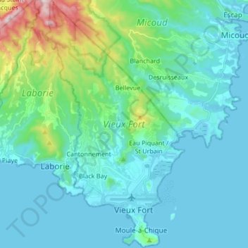
Name: Vieux Fort topographic map, elevation, terrain.
Location: Vieux Fort, Saint Lucia (13.70762 -61.00044 13.83816 -60.92512)
Average elevation: 325 ft
Minimum elevation: 0 ft
Maximum elevation: 2,067 ft
Other topographic maps
Click on a map to view its topography, its elevation and its terrain.
Pomme
Saint Lucia > Vieux Fort > Cantonnement
Pomme, Cantonnement, Vieux Fort, LC11 101, Saint Lucia
Average elevation: 243 ft