
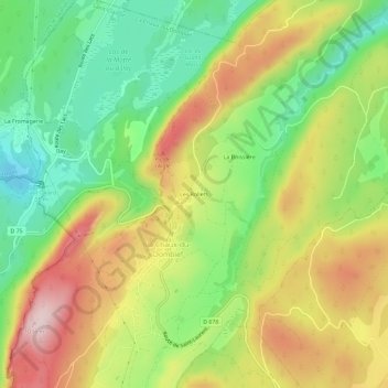
Les Rollets topographic map
Interactive map
Click on the map to display elevation.
About this map
Name: Les Rollets topographic map, elevation, terrain.
Average elevation: 2,825 ft
Minimum elevation: 2,356 ft
Maximum elevation: 3,396 ft
Other topographic maps
Click on a map to view its topography, its elevation and its terrain.
La Boissière
France > Bourgogne-Franche-Comté > Jura > La Chaux-du-Dombief
La Boissière, La Chaux-du-Dombief, Saint-Claude, Jura, Bourgogne-Franche-Comté, France métropolitaine, 39150, France
Average elevation: 2,812 ft
Ilay
France > Bourgogne-Franche-Comté > Jura > La Chaux-du-Dombief
Ilay, La Chaux-du-Dombief, Saint-Claude, Jura, Bourgogne-Franche-Comté, France métropolitaine, 39150, France
Average elevation: 2,703 ft