
Thank you for supporting this site ❤️
Make a donation
Make a donation
Gear up for your next adventure:
As an Amazon Associate, this site earns from qualifying purchases at no extra cost to you.
Tolata topographic map
Click on the map to display elevation.
Thank you for supporting this site ❤️
Make a donation
Make a donation
Gear up for your next adventure:
As an Amazon Associate, this site earns from qualifying purchases at no extra cost to you.
About this map
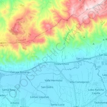
Name: Tolata topographic map, elevation, terrain.
Location: Tolata, Germán Jordán, Cochabamba, Bolivia (-17.56514 -66.08282 -17.47743 -65.94103)
Average elevation: 9,839 ft
Minimum elevation: 8,832 ft
Maximum elevation: 12,749 ft
Thank you for supporting this site ❤️
Make a donation
Make a donation
Gear up for your next adventure:
As an Amazon Associate, this site earns from qualifying purchases at no extra cost to you.