
White Mountain topographic map
Interactive map
Click on the map to display elevation.
About this map
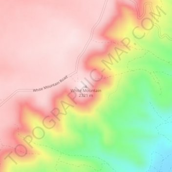
Name: White Mountain topographic map, elevation, terrain.
Location: White Mountain, Sweetwater County, Wyoming, United States (41.57797 -109.32018 41.57807 -109.32008)
Average elevation: 7,119 ft
Minimum elevation: 6,234 ft
Maximum elevation: 7,638 ft
Other topographic maps
Click on a map to view its topography, its elevation and its terrain.
Creston
United States > Wyoming > Sweetwater County
Creston, Sweetwater County, Wyoming, United States
Average elevation: 7,093 ft
North Rock Springs
United States > Wyoming > Sweetwater County
North Rock Springs, Sweetwater County, Wyoming, United States
Average elevation: 6,834 ft
Arrowhead Springs
United States > Wyoming > Sweetwater County > Arrowhead Springs
Arrowhead Springs, Sweetwater County, Wyoming, United States
Average elevation: 6,745 ft
Rock Springs
United States > Wyoming > Sweetwater County
Rock Springs, Sweetwater County, Wyoming, 82901, United States
Average elevation: 6,640 ft
Table Rock
United States > Wyoming > Sweetwater County
Table Rock, Sweetwater County, Wyoming, United States
Average elevation: 6,923 ft
Rock Springs
United States > Wyoming > Sweetwater County > Rock Springs
Rock Springs, Sweetwater County, Wyoming, 82901, United States
Average elevation: 6,749 ft
Point of Rocks
United States > Wyoming > Sweetwater County
Point of Rocks, Sweetwater County, Wyoming, United States
Average elevation: 6,759 ft
Green River
United States > Wyoming > Sweetwater County
Green River, Sweetwater County, Wyoming, 82935, United States
Average elevation: 6,512 ft