
Aagtdorp topographic map
Interactive map
Click on the map to display elevation.
About this map
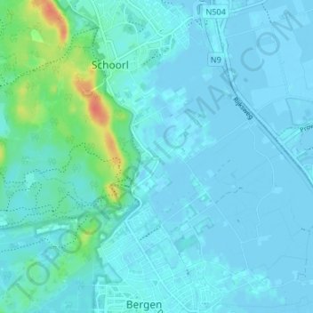
Name: Aagtdorp topographic map, elevation, terrain.
Average elevation: 20 ft
Minimum elevation: -10 ft
Maximum elevation: 144 ft
Other topographic maps
Click on a map to view its topography, its elevation and its terrain.
Schoorlse Duinen
Nederland > Noord-Holland > Schoorl > Camperduin
Schoorlse Duinen, Heereweg, Camperduin, Schoorl, Bergen, Noord-Holland, Nederland, 1871 GH, Nederland
Average elevation: 26 ft
Bregtdorp
Nederland > Noord-Holland > Schoorl
Bregtdorp, Schoorl, Bergen, Noord-Holland, Nederland, 1871 EL, Nederland
Average elevation: 23 ft
Camperduin
Nederland > Noord-Holland > Schoorl
Camperduin, Schoorl, Bergen, Noord-Holland, Nederland, 1871 GT, Nederland
Average elevation: 13 ft