Geolocate

Okara topographic map

Click on the map to display elevation.

About this map

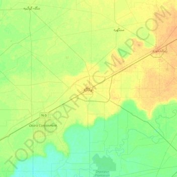
Name: Okara topographic map, elevation, terrain.

Location: Okara, Punjab, 42000, Pakistan (30.64913 73.28933 30.96913 73.60933)

Average elevation: 581 ft

Minimum elevation: 545 ft

Maximum elevation: 620 ft

Gear up for your next adventure:

🔦Powerful Headlamps - Ultra-bright hands-free lighting for night navigation
🧣Merino Neck Gaiters - Multi-functional headwear for wind and sun protection
🔭Compact Binoculars - HD vision for scouting terrain and identifying distant landmarks
🧯Emergency Survival Kit - All‑in‑one survival essentials for the backcountry
🧷Carabiner Set - Durable clips for gear attachment

As an Amazon Associate, this site earns from qualifying purchases at no extra cost to you.