Geolocate

Haarlem topographic map

Click on the map to display elevation.

About this map

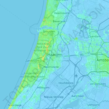
Name: Haarlem topographic map, elevation, terrain.

Location: Haarlem, North Holland, Netherlands, 2011MJ, Netherlands (52.22853 4.47880 52.54853 4.79880)

Average elevation: 0 ft

Minimum elevation: -26 ft

Maximum elevation: 144 ft

Gear up for your next adventure:

🧺Microfiber Travel Towels - Compact and fast-drying towels for trail use
🔭Stargazing Telescopes - Perfect for camping in low-light pollution areas shown on maps
👖Convertible Hiking Pants - Versatile zip-off pants for changing altitudes and temperatures
🔥Fast-Boil Camping Stoves - Efficient cooking systems for quick trail meals
🛠️Outdoor Gear Repair Kit - Essential tools to fix gear on the trail

As an Amazon Associate, this site earns from qualifying purchases at no extra cost to you.