Geolocate

Bani Walid topographic map

Click on the map to display elevation.

About this map

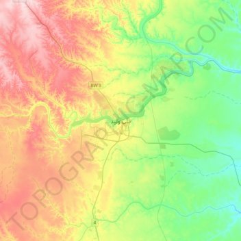
Name: Bani Walid topographic map, elevation, terrain.

Location: Bani Walid, Libya (31.59998 13.85732 31.91998 14.17732)

Average elevation: 817 ft

Minimum elevation: 492 ft

Maximum elevation: 1,296 ft

Gear up for your next adventure:

🧴Hand Sanitizer - Keep hands clean while hiking
🪶Thermal Camp Blanket - Extra warmth for cold nights
🕶️GPS Smartphone Mount - Secure mount for phone navigation
🥾Men's Hiking Boots - Durable, waterproof footwear for rugged terrain and steep inclines
📶Satellite Messenger - Communication device off‑grid

As an Amazon Associate, this site earns from qualifying purchases at no extra cost to you.