
Make a donation
Gear up for your next adventure:
As an Amazon Associate, this site earns from qualifying purchases at no extra cost to you.
Piney Mountain topographic map
Click on the map to display elevation.
Make a donation
Gear up for your next adventure:
As an Amazon Associate, this site earns from qualifying purchases at no extra cost to you.
About this map
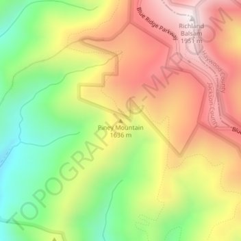
Name: Piney Mountain topographic map, elevation, terrain.
Average elevation: 5,180 ft
Minimum elevation: 3,973 ft
Maximum elevation: 6,342 ft
Jackson County trails, hiking, mountain biking, running and outdoor activities
Make a donation
Gear up for your next adventure:
As an Amazon Associate, this site earns from qualifying purchases at no extra cost to you.
Other topographic maps
Click on a map to view its topography, its elevation and its terrain.
Make a donation
Gear up for your next adventure:
As an Amazon Associate, this site earns from qualifying purchases at no extra cost to you.
Panthertown Valley Backcountry Area
United States > North Carolina > Jackson County
Average elevation: 3,671 ft
Wolftown Community
United States > North Carolina > Jackson County > Wolftown Community
Average elevation: 3,665 ft
Make a donation
Gear up for your next adventure:
As an Amazon Associate, this site earns from qualifying purchases at no extra cost to you.