
Make a donation
Gear up for your next adventure:
As an Amazon Associate, this site earns from qualifying purchases at no extra cost to you.
Ain Zaatout topographic map
Click on the map to display elevation.
Make a donation
Gear up for your next adventure:
As an Amazon Associate, this site earns from qualifying purchases at no extra cost to you.
Ain Zaatout
It is located at 35.14° North, 5.83° East, at the southern edge of the Saharan Atlas between the provinces of Batna and Biskra. The region is largely rocky with an average altitude of more than 900 metres (2,953 feet) above sea level.
Make a donation
Gear up for your next adventure:
As an Amazon Associate, this site earns from qualifying purchases at no extra cost to you.
About this map
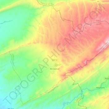
Name: Ain Zaatout topographic map, elevation, terrain.
Location: Ain Zaatout, El Kantara District, Biskra, Algeria (35.08795 5.74519 35.25192 5.96611)
Average elevation: 3,136 ft
Minimum elevation: 1,421 ft
Maximum elevation: 5,709 ft
Make a donation
Gear up for your next adventure:
As an Amazon Associate, this site earns from qualifying purchases at no extra cost to you.