
Make a donation
Gear up for your next adventure:
As an Amazon Associate, this site earns from qualifying purchases at no extra cost to you.
Bad Hersfeld topographic map
Click on the map to display elevation.
Make a donation
Gear up for your next adventure:
As an Amazon Associate, this site earns from qualifying purchases at no extra cost to you.
Bad Hersfeld
The Flugplatz Johannesberg has the status of Special Airfield. The runway, some 671 m long and 18 m wide, is paved with asphalt and oriented in a north–south direction. The airfield lies on the Johannesberg in the like-named outlying centre at an elevation of 284 m above sea level.
Make a donation
Gear up for your next adventure:
As an Amazon Associate, this site earns from qualifying purchases at no extra cost to you.
About this map
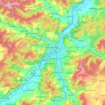
Name: Bad Hersfeld topographic map, elevation, terrain.
Average elevation: 1,001 ft
Minimum elevation: 623 ft
Maximum elevation: 1,611 ft
Make a donation
Gear up for your next adventure:
As an Amazon Associate, this site earns from qualifying purchases at no extra cost to you.
Other topographic maps
Click on a map to view its topography, its elevation and its terrain.
Bad Hersfeld
Germany > Hesse > Landkreis Hersfeld-Rotenburg
The Flugplatz Johannesberg has the status of Special Airfield. The runway, some 671 m long and 18 m wide, is paved with asphalt and oriented in a north–south direction. The airfield lies on the Johannesberg in the like-named outlying centre at an elevation of 284 m above sea level.
Average elevation: 922 ft