
Gräfenthal topographic map
Interactive map
Click on the map to display elevation.
About this map
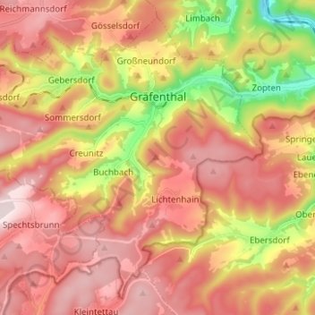
Name: Gräfenthal topographic map, elevation, terrain.
Average elevation: 1,926 ft
Minimum elevation: 1,007 ft
Maximum elevation: 2,569 ft
Other topographic maps
Click on a map to view its topography, its elevation and its terrain.
Sommersdorf
Deutschland > Thüringen > Landkreis Saalfeld-Rudolstadt > Gräfenthal > Sommersdorf
Sommersdorf, Gräfenthal, Schiefergebirge, Landkreis Saalfeld-Rudolstadt, Thüringen, 98743, Deutschland
Average elevation: 1,860 ft