
El Omrane topographic map
Interactive map
Click on the map to display elevation.
About this map
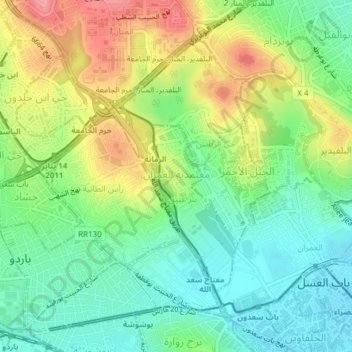
Name: El Omrane topographic map, elevation, terrain.
Location: El Omrane, Tunis, 1030, Tunisie (36.80883 10.13821 36.83323 10.17623)
Average elevation: 148 ft
Minimum elevation: 23 ft
Maximum elevation: 344 ft
Other topographic maps
Click on a map to view its topography, its elevation and its terrain.
Sidi Bou Saïd
Tunisie > Tunis > Sidi Bou Saïd
Sidi Bou Saïd, Sidi Bou Said, Carthage, Tunis, 2026, Tunisie
Average elevation: 43 ft
Sebkha Séjoumi
Sebkha Séjoumi, RR 39 طج, Tunis, 25 Juillet, Fouchana, Tunis, 1145, Tunisie
Average elevation: 59 ft
golfe de Tunis
golfe de Tunis, Carthage, Carthage Plage, Carthage, Tunis, Tunisie
Average elevation: 98 ft
Ech-Charguia
Ech-Charguia, Cité El Khadra, Tunis, 2035, Tunisie
Average elevation: 13 ft