
Lakhimpur topographic map
Interactive map
Click on the map to display elevation.
About this map
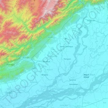
Name: Lakhimpur topographic map, elevation, terrain.
Location: Lakhimpur, Assam, India (26.82827 93.69810 27.52579 94.62726)
Average elevation: 1,424 ft
Minimum elevation: 226 ft
Maximum elevation: 9,439 ft
Other topographic maps
Click on a map to view its topography, its elevation and its terrain.
Subansiri (Pt-I)
Subansiri (Pt-I), Lakhimpur, Assam, 787053, India
Average elevation: 295 ft