
دهستان بناجوی غربی topographic map
Interactive map
Click on the map to display elevation.
About this map
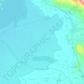
Name: دهستان بناجوی غربی topographic map, elevation, terrain.
Average elevation: 4,229 ft
Minimum elevation: 4,147 ft
Maximum elevation: 6,276 ft
Other topographic maps
Click on a map to view its topography, its elevation and its terrain.
Bonab
Iran > East Azerbaijan Province > Bonab County > دهستان بناجوی غربی
Bonab, دهستان بناجوی غربی, بخش مرکزی, Bonab County, East Azerbaijan Province, 55517-58871, Iran
Average elevation: 4,229 ft