
Thank you for supporting this site ❤️
Make a donation
Make a donation
Gear up for your next adventure:
As an Amazon Associate, this site earns from qualifying purchases at no extra cost to you.
Guatapurí topographic map
Click on the map to display elevation.
Thank you for supporting this site ❤️
Make a donation
Make a donation
Gear up for your next adventure:
As an Amazon Associate, this site earns from qualifying purchases at no extra cost to you.
About this map
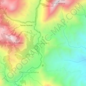
Name: Guatapurí topographic map, elevation, terrain.
Location: Guatapurí, Valledupar, Cesar, RAP Caribe, Colombia (10.70794 -73.41218 10.74794 -73.37218)
Average elevation: 4,298 ft
Minimum elevation: 2,812 ft
Maximum elevation: 6,260 ft
Thank you for supporting this site ❤️
Make a donation
Make a donation
Gear up for your next adventure:
As an Amazon Associate, this site earns from qualifying purchases at no extra cost to you.