
Marmong Point topographic map
Interactive map
Click on the map to display elevation.
About this map
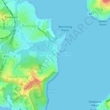
Name: Marmong Point topographic map, elevation, terrain.
Average elevation: 36 ft
Minimum elevation: -7 ft
Maximum elevation: 223 ft
Other topographic maps
Click on a map to view its topography, its elevation and its terrain.
Kotara
Australia > New South Wales > Newcastle
Kotara, Newcastle, Newcastle-Maitland, Newcastle City Council, 2289, Australia
Average elevation: 223 ft
Teralba
Australia > New South Wales > Newcastle
Teralba, Newcastle, Newcastle-Maitland, Lake Macquarie City Council, 2284, Australia
Average elevation: 75 ft
Jewells
Australia > New South Wales > Newcastle
Jewells, Newcastle, Newcastle-Maitland, Lake Macquarie City Council, 2280, Australia
Average elevation: 89 ft