
Muros topographic map
Interactive map
Click on the map to display elevation.
About this map
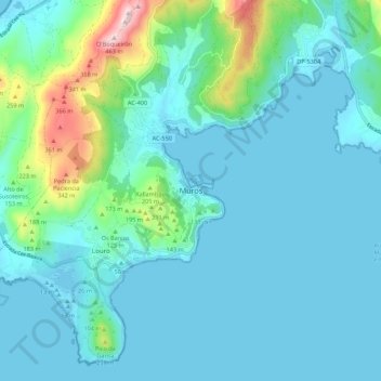
Name: Muros topographic map, elevation, terrain.
Location: Muros, La Coruña, Galicia, 15250, España (42.73441 -9.09754 42.81441 -9.01754)
Average elevation: 230 ft
Minimum elevation: -10 ft
Maximum elevation: 1,516 ft
Other topographic maps
Click on a map to view its topography, its elevation and its terrain.
Illa de Anguieiro
Illa de Anguieiro, Carnota, Muros, La Coruña, Galicia, 15292, España
Average elevation: 331 ft
Outeiro do Milladoiro
Outeiro do Milladoiro, Muros, La Coruña, Galicia, 15293, España
Average elevation: 883 ft