
Cúc Phương National Park topographic map
Interactive map
Click on the map to display elevation.
About this map
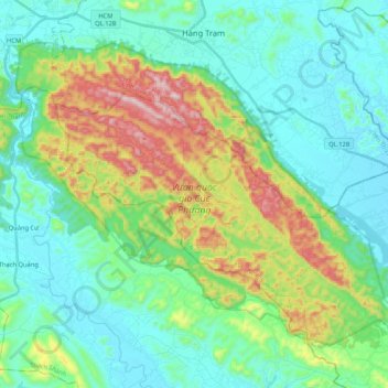
Name: Cúc Phương National Park topographic map, elevation, terrain.
Average elevation: 525 ft
Minimum elevation: 20 ft
Maximum elevation: 1,991 ft
Cúc Phương is situated in the foothills of the northern Annamite Range. The park consists of verdant karst mountains and lush valleys. Elevation varies from 150 meters (500 feet) to 656 m (2,152 feet) at the summit of May Bac Mountain, or Silver Cloud Mountain. The limestone mountains house numerous caves, many of which are accessible for exploration.