
Taşdelen Mahallesi topographic map
Interactive map
Click on the map to display elevation.
About this map
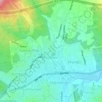
Name: Taşdelen Mahallesi topographic map, elevation, terrain.
Location: Taşdelen Mahallesi, Çekmeköy, Istanbul, Marmara Region, Turkey (41.02680 29.22572 41.03899 29.23647)
Average elevation: 446 ft
Minimum elevation: 308 ft
Maximum elevation: 850 ft
Other topographic maps
Click on a map to view its topography, its elevation and its terrain.
Soğukpınar Mahallesi
Soğukpınar Mahallesi, Çekmeköy, Istanbul, Marmara Region, Turkey
Average elevation: 410 ft
Merkez Mahallesi
Merkez Mahallesi, Çekmeköy, Istanbul, Marmara Region, 34782, Turkey
Average elevation: 551 ft