
Rio Cuautla topographic map
Interactive map
Click on the map to display elevation.
About this map
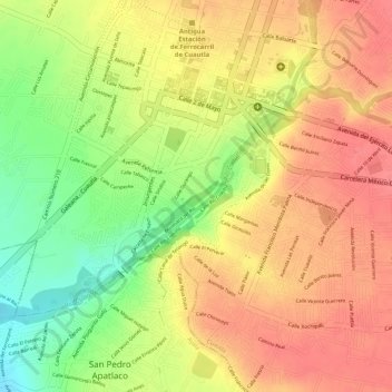
Name: Rio Cuautla topographic map, elevation, terrain.
Location: Rio Cuautla, Cuautla, Morelos, 62740, México (18.80042 -98.95788 18.80919 -98.94900)
Average elevation: 4,252 ft
Minimum elevation: 4,104 ft
Maximum elevation: 4,334 ft
Other topographic maps
Click on a map to view its topography, its elevation and its terrain.
Parque Galeana
México > Morelos > Cuautla > Cuautla
Parque Galeana, Cuautla, Morelos, 62748, México
Average elevation: 4,465 ft
Parque Morelos
México > Morelos > Cuautla > Cuautla
Parque Morelos, Cuautla, Morelos, 62748, México
Average elevation: 4,462 ft